The following document library contains all the relevant information regarding the Fishermans Bend project.
To request an accessible Word version of a publication, email fishermansbend@ecodev.vic.gov.au
Water Sensitive City Strategy
Water Sensitive City Strategy (PDF)
Urban Ecology Study
Fishermans Bend Urban Ecology Study Volume 1
Fishermans Bend Urban Ecology Study Volume 2
Building Biodiversity into the Urban Fabric - a case study in applying BSU
Fishermans Bend Biodiversity Report
Case Studies
Water Sensitive Drainage and Flood Strategy
Appendix A Documentation of the Development of the Hybrid Approach - Collaborative Process
Appendix B (part 1) Docmt of the Dev of the Hybrid Approach - Cross-Sect and Pres
Appendix B (part 2) Docmt of the Dev of the Hybrid Approach - Cross-Sect and Pres
Appendix B (part 3) Docmt of the Dev of the Hybrid Approach - Cross-Sect and Pres
Appendix B (part 4) Docmt of the Dev of the Hybrid Approach - Cross-Sect and Pres
Appendix C Fishermans Bend Existing New Road Use Hierarchy
Appendix D Hybrid Strategy Development
Appendix E Groundwater Discussion Memorandum
Appendix F MEM-Rainwater Tank Benefits
Appendix H MEM-0-Pump stations
Appendix I Costing Framework Memorandum
Appendix J MEM-2-Preliminary Cost Estimates for ICP
Appendix K Modelling Review Memorandum
Appendix M Comprehensive Strategy Information
IWM Options and WRP concept design
Minister for Planning part A response
Letter enc part A submission for Minister PDF, 76.18 KB
Minister for Planning part A response PDF, 2156.84 KB
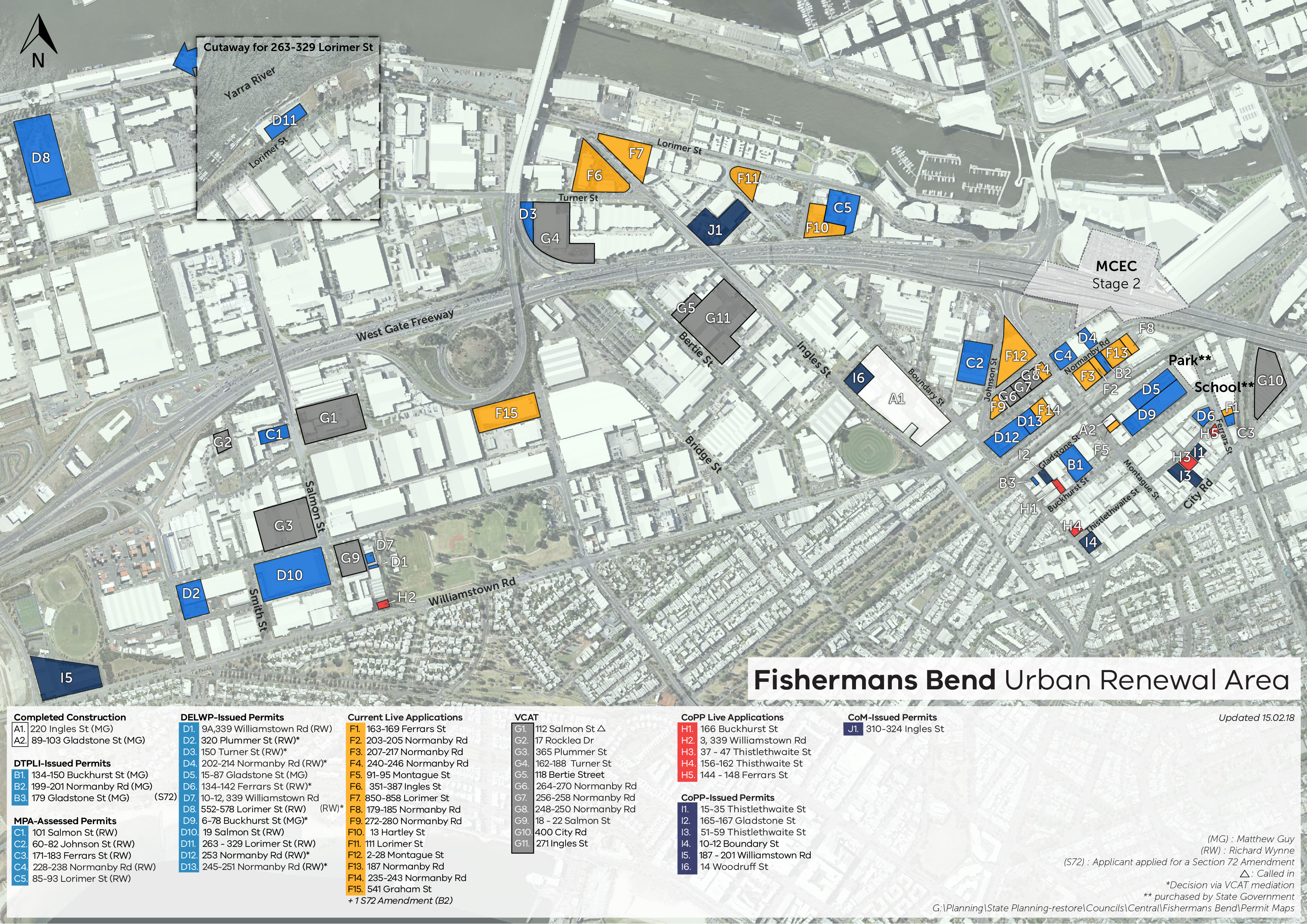
Permit activity map JPG, 5736.14 KB
Submission spreadsheet PDF, 1222.47 KB
Amended planning scheme documentation
Melbourne GC81 22_lpp27_melb - Part A submission PDF, 561.49 KB
Melbourne GC81 37_04s4_melb - Part A submission PDF, 5196.33 KB
Melbourne GC81 43_02s67_melb - Part A submission NO TRACK CHANGES PDF, 2402.06 KB
Melbourne GC81 43_02s67_melb - Part A submission PDF, 5571.17 KB
Melbourne GC81 45_09s13_melb - Part A submission PDF, 490.87 KB
Port Phillip GC81 22_lpp15_port - Part A submission PDF, 566.23 KB
Port Phillip GC81 37_04s1_port - Part A submission PDF, 697.1 KB
Port Phillip GC81 43_02s30_port - Part A submission NO TRACK CHANGES PDF, 8140.37 KB
Port Phillip GC81 43_02s30_port - Part A submission PDF, 5399.21 KB
Port Phillip GC81 45_09s1_port - Part A submission PDF, 491.35 KB
3D modelling joint conclave
Letter to panel and parties - joint conclave PDF, 149.77 KB
Joint conclave statement PDF, 134.81 KB
Minister for Planning Part B response
For the Minister for Planning's part B response, see the Fishermans Bend Planning Review Panel tabled documents
Site inspection documents
On 20 November 2017, the Planning Review Panel undertook a site inspection with the Fishermans Bend Taskforce. The Taskforce provided the following documents to the panel:
Panel bus tour map PDF, 5434.57 KB
Site tour stop notes PDF, 392.05 KB
Expert evidence
Minister for Planning
Development viability - Luke Mackintosh PDF, 4394.9 KB
Economics - Julian Szafraniec PDF, 1046.29 KB
Economics - Julian Szafraniec - response to panel request for further information PDF, 387.12 KB
Open space - Joanna Thompson PDF, 8031.2 KB
Planning - John Glossop PDF, 972.44 KB
Strategic transport - Framework peer review - Will Fooks PDF, 2958.81 KB
Strategic transport - Will Fooks - Powerpoint presentation PDF, 2164.84 KB
Strategic transport - Integrated Transport Plan peer review - John Kiriakidis PDF, 4375.2 KB
Strategic transport - John Kiriakidis - Powerpoint presentation PDF, 2810.4 KB
Urban design - Leanne Hodyl PDF, 8015.87 KB
Urban design - Leanne Hodyl - addendum 1 PDF, 284.98 KB
Urban design - Leanne Hodyl - addendum 2 PDF, 11915.97 KB
Urban design - Leanne Hodyl - addendum 3 PDF, 4418.29 KB
Urban design - Leanne Hodyl - addendum 4 PDF, 392.5 KB
Urban design - Leanne Hodyl - addendum 5 PDF, 6251.74 KB
Urban design - Donald Bates PDF, 450.96 KB
Urban design - Donald Bares - addendum 1 PDF, 1744.15 KB
City of Melbourne
Infrastructure funding and delivery - City of Melbourne - Paul Shipp PDF, 292.73 KB
Sustainability - Euan Williamson PDF, 2815.39 KB
Town planning - Rob Milner PDF, 833.72 KB
Urban design - Koos de Keijzer PDF, 4888.52 KB
City of Port Phillip
Affordable housing - Marcus Spiller PDF, 706.76 KB
Affordable housing - Marcus Spiller - footnote 8 PDF, 1794.74 KB
Infrastructure funding and delivery - City of Port Phillip - Paul Shipp PDF, 290.69 KB
Flooding and drainage - Tom Patterson PDF, 2677 KB
Funding and financing infrastructure case studies - Mesh PDF, 9385.28 KB
Funding and financing infrastructure case studies - Mesh - Appendices 1-4 PDF, 9448.77 KB
Funding and financing infrastructure case studies - Mesh - Appendices 5-6 PDF, 13584.61 KB
Funding and financing infrastructure case studies - Mesh - Appendices 7-8 PDF, 1621.97 KB
Urban design - Simon McPherson PDF, 16521.08 KB
Submitters
Submitter 71
Transport engineering - Charmaine Dunstan PDF, 5966.16 KB
Submitters 71, 79, 104, 130, 162 and 196
Urban design - Mark Sheppard - Lorimer PDF, 8560.41 KB
Submitters 71, 79, 87, 90, 91, 94, 95, 96, 104, 120, 130, 131, 149, 150, 162, 173, 175, 182, 196, 207, 217, 242 and 250
Urban design - Mark Sheppard PDF, 14019.54 KB
Submitters 71, 87, 120, 104, 149, 175, 207, 196, 217 and 250
Town planning - Andrew Biasci PDF, 1153.62 KB
Town planning - Andrew Biasci - Attachment 1 - Expert witness declaration PDF, 371.66 KB
Town planning - Andrew Biasci - Attachment 2 - Client group PDF, 37.31 KB
Transport planning - Charmaine Dunstan PDF, 3856.92 KB
Submitters 87, 90, 91, 94, 95, 96, 120, 131, 173 and 207
Urban design - Mark Sheppard - Montague PDF, 12503.36 KB
Submitters 89, 163 and 165
Town planning - Marco Negri PDF, 4663.06 KB
Submitters 131, 182, 242 and 250
Urban design - Mark Sheppard - Sandridge PDF, 8015.12 KB
Submitter 147
Town planning - David Barnes PDF, 8022.02 KB
Submitter 149
Urban design - Catherine Heggen PDF, 4514.16 KB
Submitter 150
Environmental wind conditions - Michael Eaddy and William Melbourne PDF, 2174.74 KB
Submitter 175
Urban design - Catherine Heggen PDF, 4140.71 KB
Submitters 217, 150 and 131
Urban design - Mark Sheppard - Wirraway PDF, 7883.11 KB
Submitter 220
Planning - Brendan Rogers PDF, 4051.45 KB
Transport planning - Charmaine Dunstan PDF, 6577.88 KB
Various submitters
Economics - Ian Shimmin PDF, 2312.03 KB
Town planning - Stuart McGurn - Part A PDF, 13700.67 KB
Town planning - Stuart McGurn - Part B PDF, 12778.61 KB
Planning Review Panel Reports
Planning Review Panel – Report 1 Volume 1 DOCX, 13159.31 KB
Planning Review Panel – Report 1 Volume 2 DOCX, 9895.21 KB
Planning Review Panel – Report 2 – Lorimer Precinct DOCX, 6934.68 KB
Planning Review Panel – Report 3 – Montague Precinct DOCX, 4636.68 KB
Planning Review Panel – Report 4 – Sandridge Precinct DOCX, 5237.69 KB
Planning Review Panel – Report 5 – Wirraway Precinct DOCX, 4365.33 KB
Supplementary information
Minister for Planning supplementary part B submission
Supplementary Part B Submission for the Minister for Planning PDF, 1244.97 KB
Combined CCZ Schedule - Minister for Planning revisions to Doc 66e - 28 March 2018 PDF, 1764 KB
Minister for Planning revised maps for CCZ DDO and MSS - 29 March 2018 PDF, 2210.44 KB
Supplementary information notes (SIN)
SIN 1 - The proponent for draft Amendment GC81 PDF, 68.97 KB
SIN 2 - Rationale for resident population target of 80,000 PDF, 283.34 KB
SIN 2 - Attachment 1 PDF, 104.2 KB
SIN 2 - Attachment 2 PDF, 207.49 KB
SIN 2 - Attachment 3 PDF, 3078.19 KB
SIN 2 - Attachment 4 PDF, 607.78 KB
SIN 4 - Linear park provision PDF, 15.89 KB
SIN 4 - Attachment 1 PDF, 4290.88 KB
SIN 5 - Application of PAO and relationship with s201F of PE Ac PDF, 132.33 KB
SIN 5 - Attachment 1 PDF, 1836.43 KB
SIN 6 - FAU under C270 controls PDF, 163.01 KB
SIN 6 - Attachment 1 PDF, 51.04 KB
SIN 6 - Attachment 2 PDF, 1434.35 KB
SIN 6 - Attachment 3 PDF, 27.97 KB
SIN 6 - Attachment 4 PDF, 351.36 KB
SIN 6 - Attachment 5 PDF, 7292.91 KB
SIN 7 - FAU and community infrastructure PDF, 121.78 KB
SIN 7 - Attachment 1 PDF, 187.18 KB
SIN 8 - Affordable housing PDF, 200.35 KB
SIN 8 - Attachment 1 PDF, 120.26 KB
SIN 8 - Attachment 2 PDF, 203.42 KB
SIN 8 - Attachment 3 PDF, 229.35 KB
SIN 9 - Responding to Port Phillip on community infrastructure PDF, 104.83 KB
SIN 10 - Attachment 1 PDF, 109.71 KB
SIN 10 - Attachment 2 PDF, 114.62 KB
SIN 10 - Attachment 3 PDF, 115.5 KB
SIN 11 - Precinct plans PDF, 134.92 KB
SIN 12 - Planning provisons incorporating design review panel process PDF, 130.31 KB
SIN 12 - Attachment 1 PDF, 171.46 KB
SIN 12 - Attachment 2 PDF, 231.83 KB
SIN 13 - Policies encouraging housing diversity PDF, 103.5 KB
Report to the Minister for Planning on draft Fishermans Bend Framework PDF, 8094.33 KB
Fishermans Bend Ministerial Advisory Committee Terms of Reference April 2016 PDF, 3544.34 KB
Ministerial Advisory Committee Report - October 2015 PDF, 841.49 KB
Ministerial Advisory Committee Report One - Recommendations and Ministerial Response PDF, 610.25 KB
Drainage Reports
Framework background reports
Fishermans Bend Integrated Transport Plan, 2017 - Transport for Victoria PDF, 3252.94 KB
Fishermans Bend Aboriginal Cultural Values Interpretation Strategy, 2017 - Extent PDF, 9275 KB
Fishermans Bend Baseline Utility Assessment Report, 2016 - GHD - Part A PDF, 1036.89 KB
Fishermans Bend Baseline Utility Assessment Report, 2016 - GHD - Part B PDF, 9928.04 KB
Fishermans Bend Buffer Assessment, 2016 - GHD - Part A PDF, 9792.86 KB
Fishermans Bend Buffer Assessment, 2016 - GHD - Part B PDF, 2738.92 KB
Fishermans Bend Community Infrastructure Plan 2017, 2017 - Fishermans Bend Taskforce PDF, 7244.51 KB
Fishermans Bend Economic and Employment Study, 2016 - SGS PDF, 6770.94 KB
Fishermans Bend Population and Demographic Report, 2017 - DELWP PDF, 2674.18 KB
Fishermans Bend Heritage Study, 2016 - Biosis PDF, 7473.07 KB
Life on the bend - social history study - Context PDF, 9967.28 KB
Social history resources: a guide - Context PDF, 591.86 KB
Fishermans Bend Public Space Strategy, 2017 - Planisphere - Part A
PDF, 7965.49 KB
Fishermans Bend Public Space Strategy, 2017 - Planisphere - Part B PDF, 7149.95 KB
Fishermans Bend Public Space Strategy, 2017 - Planisphere - Part C PDF, 7869.16 KB
Fishermans Bend Smart Cities Framework, 2016 - WSP Parsons Brinckerhoff PDF, 3906.32 KB
Fishermans Bend Sustainability Strategy, 2017- Fishermans Bend Taskforce PDF, 7895.59 KB
Urban Design Strategy, 2017 - Hodyl & Co PDF, 9365.78 KB
Fishermans Bend Waste and Resource Recovery Strategy, 2017 - MWRRG PDF, 1088.08 KB
Fishermans Bend Baseline Groundwater Quality Assessment, 2016 - AECOM
Fishermans Bend Climate Readiness Strategy - Organising Framework 201, prepared by AECOM/Rambol
Fishermans Bend Net Zero Emissions Strategy Baseline Assessment 2018 - Point Advisory/Aurecon
Fishermans Bend Net Zero Carbon Strategy 2018 - Point Advisory
Fishermans Bend Review of Sustainability Standards 2018 - ARUP
Fishermans Bend Urban Renewal Area Retail Assessment 2018 - Essential Economics
Fishermans Bend Urban Renewal Area Retail Assessment - Detailed Model Results 2018
Additional background reports
Governance and the Smart City - EoT 2016 PDF, 835.08 KB
Public space strategy - stage 3 final gap analysis - Planisphere 2017 PDF, 3162.13 KB
Transport reports
Letter to panel - response to direction 23 PDF, 122.03 KB
1 - Fishermans Bend public transport and active mode link report PDF, 6651.7 KB
2 - Improving connectivity in Fishermans Bend (partially redacted) - Jacobs PDF, 9549.63 KB
3 - Public transport active mode link and connectivity study (partially redacted) - Jacobs - available in two parts
3.1 - Public transport active mode link and connectivity study (partially redacted) - Jacobs - part 1 (p1-40) PDF, 11910.79 KB
3.2 - Public transport active mode link and connectivity study (partially redacted) - Jacobs - part 2 (p41-79) PDF, 16985.67 KB
4 - Freight Corridor advisory Report - redacted in part PDF, 3210.8 KB
5 - Fishermans Bend Metro Alignment and Feasibility Options Report partially redacted - available in six parts
5.1 - Fishermans Bend Metro Alignment and Feasibility Options Report - part 1 (p1-98) PDF, 17249.84 KB
5.2 - Fishermans Bend Metro Alignment and Feasibility Options Report - part 2 (p99-116) PDF, 6238.21 KB
5.3 - Fishermans Bend Metro Alignment and Feasibility Options Report - part 3 (p117-132) PDF, 8185.57 KB
5.4 - Fishermans Bend Metro Alignment and Feasibility Options Report - part 4 (p133-150) PDF, 8416.07 KB
5.5 - Fishermans Bend Metro Alignment and Feasibility Options Report - part 5 (p151-168) PDF, 8853.96 KB
5.6 - Fishermans Bend Metro Alignment and Feasibility Options Report - part 6 (p169 to 231) PDF, 9642.21 KB
6 - Fishermans Bend tram extension VITM modelling report - DEDJTR PDF, 18026.63 KB
7 - Microsimulation modelling of Port Junction and Spencer/Clarendon corridor - GTA PDF, 8131.86 KB
8 - Fishermans Bend precinct car parking opportunities - GTA PDF, 3040.11 KB
9 - Fishermans Bend strategic transport peer review - GTA PDF, 5843.92 KB
10 - Fishermans Bend Water Transport Feasibility Study Report PDF, 2662.5 KB
11 - Yarras Edge Marina Movement and Berthing Analysis Report PDF, 5453.23 KB
13 - Draft Integrated Transport Plan for Fishermans Bend (2013) - available in five parts
13.1 - Draft Integrated Transport Plan for Fishermans Bend (2013) - part 1 (p1-10) PDF, 8765.48 KB
13.2 - Draft Integrated Transport Plan for Fishermans Bend (2013) - part 2 (p11-30) PDF, 7326.44 KB
13.3 - Draft Integrated Transport Plan for Fishermans Bend (2013) - part 3 (p31-60) PDF, 7557.33 KB
13.4 - Draft Integrated Transport Plan for Fishermans Bend (2013) - part 4 (p61-90) PDF, 9688.08 KB
13.5 - Draft Integrated Transport Plan for Fishermans Bend (2013) - part 5 (p91-128) PDF, 9701.98 KB
14 - Fishermans Bend land use scenarios for VITM - SGS PDF, 8155.72 KB
Information sheet
GC81 Draft Planning Scheme Amendment Information Sheet
(updated 1 November 2017 to correct minor errors)
Draft clauses and schedules
Melbourne Planning Scheme
Melbourne Clause 21.02 municipal profile
Melbourne Clause 21.04 settlement
Melbourne Clause 21.08 economic development
Melbourne Clause 21.13 urban renewal areas
Melbourne Clause 21.16 other local areas
Melbourne Clause 21.17 reference documents
Melbourne Clause 22.27 Fishermans Bend Urban Renewal Area Local Policy
Melbourne Clause 37.04 Capital City Zone Schedule 4
(Clause 37.04 updated 1 November 2017 to correct minor drafting errors)
Melbourne Clause 43.02 Design and Development Overlay Schedule 67
Melbourne Clause 45.09 Parking Overlay Schedule 13
Melbourne Clause 61.03 maps comprising part of this scheme
Melbourne Clause 81.01 table of documents incorporated in this scheme
Port Phillip Planning Scheme
Port Phillip Clause 21.01 Vision and approach
Port Phillip Clause 21.02 Port Phillip in context
Port Phillip Clause 21.03 Ecologically sustainable development
Port Phillip Clause 21.04 Land use
Port Phillip Clause 21.05 Built form
Port Phillip Clause 21.06 Neighbourhoods
Port Phillip Clause 22.15 Fishermans Bend Urban Renewal Area Local Policy
(Clause 22.15 updated 1 November 2017 to correct minor drafting errors)
Port Phillip Clause 37.04 Capital City Zone Schedule 1
Port Phillip Clause 43.02 Design and Development Overlay Schedule 30
Port Phillip Clause 43.04 Development Plan Overlay Schedule 2
Port Phillip Clause 45.09 Parking Overlay Schedule 1
Port Phillip Clause 61.03 maps comprising part of this scheme
Port Phillip Clause 81.01 table of documents incorporated in this scheme
Map sheets
Melbourne Planning Scheme
Melbourne Environmental Audit Overlay 001eaoMap07
Port Phillip Planning Scheme
Port Phillip Development Plan Overlay 001dpoMap02
Port Phillip Development Plan Overlay 002dpoMap03
Port Phillip Environmental Audit Overlay 003eaoMap01
Port Phillip Environmental Audit Overlay 004eaoMap02
Port Phillip Environmental Audit Overlay 005eaoMap03
Port Phillip Environmental Significance Overlay 006esoMap01
Supporting documents, clauses and schedules in track changes format
How to calculate FAU and public benefits in Fishermans Bend
Melbourne Planning Scheme
Melbourne Clause 21.02 municipal profile track change
Melbourne Clause 21.04 settlement track change
Melbourne Clause 21.08 economic development track change
Melbourne Clause 21.13 urban renewal areas track change
Melbourne Clause 21.16 other local areas track change
Melbourne Clause 21.17 reference documents track change
Melbourne Clause 61.03 maps comprising part of this scheme track change
Melbourne Clause 81.01 table of documents incorporated in this scheme track change
Port Phillip Planning Scheme
Port Phillip Clause 21.01 Vision and approach track change
Port Phillip Clause 21.02 Port Phillip in context track change
Port Phillip Clause 21.03 Ecologically sustainable development track change
Port Phillip Clause 21.04 Land use track change
Port Phillip Clause 21.05 Built form track change
Port Phillip Clause 21.06 Neighbourhoods track change
Port Phillip Clause 61.03 maps comprising part of this scheme track change
Port Phillip Clause 81.01 table of documents incorporated in this scheme track change
Reference Documents
Fishermans Bend Vision (September 2016) PDF, 7686.08 KB
Fishermans Bend Vision (September 2016) DOCX, 41.67 KB
Fishermans Bend Recast Vision PDF, 5181.37 KB
Fishermans Bend Map (742 KB) (pdf)
Fishermans Bend - Community Forum Report - North Port Oval (February 2016) PDF, 1167.74 KB
2013 Draft Vision for Fishermans Bend PDF, 4306.38 KB
Fishermans Bend Strategic Framework Plan (2016 update) PDF, 37583.66 KB
Previous studies and reports
Released March 2018
Communication and community engagement strategy - Capire Consulting Group 2012 PDF, 1461.2 KB
Draft development contributions options study - Urban Enterprise 2012 PDF, 17432.76 KB
Draft Fishermans Bend DCP - SGS 2013 PDF, 887.9 KB
Alternative funding study - PwC 2013 PDF, 5839.37 KB
Feasibility analysis - Macroplan Dimasi 2013 PDF, 1338.99 KB
Economic and transport policy positioning statement - Deloitte 2015 PDF, 502.24 KB
Infrastructure update - GHD 2015 PDF, 797.54 KB
Information sheet
GC81 Draft Planning Scheme Amendment Information Sheet
(updated 1 November 2017 to correct minor errors)
Draft clauses and schedules
Melbourne Planning Scheme
Melbourne Clause 21.02 municipal profile
Melbourne Clause 21.04 settlement
Melbourne Clause 21.08 economic development
Melbourne Clause 21.13 urban renewal areas
Melbourne Clause 21.16 other local areas
Melbourne Clause 21.17 reference documents
Melbourne Clause 22.27 Fishermans Bend Urban Renewal Area Local Policy
Melbourne Clause 37.04 Capital City Zone Schedule 4
(Clause 37.04 updated 1 November 2017 to correct minor drafting errors)
Melbourne Clause 43.02 Design and Development Overlay Schedule 67
Melbourne Clause 45.09 Parking Overlay Schedule 13
Melbourne Clause 61.03 maps comprising part of this scheme
Melbourne Clause 81.01 table of documents incorporated in this scheme
Port Phillip Planning Scheme
Port Phillip Clause 21.01 Vision and approach
Port Phillip Clause 21.02 Port Phillip in context
Port Phillip Clause 21.03 Ecologically sustainable development
Port Phillip Clause 21.04 Land use
Port Phillip Clause 21.05 Built form
Port Phillip Clause 21.06 Neighbourhoods
Port Phillip Clause 22.15 Fishermans Bend Urban Renewal Area Local Policy
(Clause 22.15 updated 1 November 2017 to correct minor drafting errors)
Port Phillip Clause 37.04 Capital City Zone Schedule 1
Port Phillip Clause 43.02 Design and Development Overlay Schedule 30
Port Phillip Clause 43.04 Development Plan Overlay Schedule 2
Port Phillip Clause 45.09 Parking Overlay Schedule 1
Port Phillip Clause 61.03 maps comprising part of this scheme
Port Phillip Clause 81.01 table of documents incorporated in this scheme
Map sheets
Melbourne Planning Scheme
Melbourne Environmental Audit Overlay 001eaoMap07
Port Phillip Planning Scheme
Port Phillip Development Plan Overlay 001dpoMap02
Port Phillip Development Plan Overlay 002dpoMap03
Port Phillip Environmental Audit Overlay 003eaoMap01
Port Phillip Environmental Audit Overlay 004eaoMap02
Port Phillip Environmental Audit Overlay 005eaoMap03
Port Phillip Environmental Significance Overlay 006esoMap01
Supporting documents, clauses and schedules in track changes format
How to calculate FAU and public benefits in Fishermans Bend
Melbourne Planning Scheme
Melbourne Clause 21.02 municipal profile track change
Melbourne Clause 21.04 settlement track change
Melbourne Clause 21.08 economic development track change
Melbourne Clause 21.13 urban renewal areas track change
Melbourne Clause 21.16 other local areas track change
Melbourne Clause 21.17 reference documents track change
Melbourne Clause 61.03 maps comprising part of this scheme track change
Melbourne Clause 81.01 table of documents incorporated in this scheme track change
Port Phillip Planning Scheme
Port Phillip Clause 21.01 Vision and approach track change
Port Phillip Clause 21.02 Port Phillip in context track change
Port Phillip Clause 21.03 Ecologically sustainable development track change
Port Phillip Clause 21.04 Land use track change
Port Phillip Clause 21.05 Built form track change
Port Phillip Clause 21.06 Neighbourhoods track change
Port Phillip Clause 61.03 maps comprising part of this scheme track change
Port Phillip Clause 81.01 table of documents incorporated in this scheme track change
Draft Vision and Design Guidelines
The following background reports were commissioned by Places Victoria to inform preparation of the 2013 Draft Vision and Design Guidelines for Fishermans Bend.
They have been prepared by experts and consider infrastructure requirements, social and community outcomes, urban context and development opportunities.
Some of these are technical in nature, such as the geotechnical study or land contamination report, and report on the nature of the environment and development capability and options. Others are more aspirational and make recommendations as to strategies to manage built form, community engagement or infrastructure options.
These studies were used in the development of the current Fishermans Bend Strategic Framework Plan. Each report is summarised below and can be accessed in full by clicking the relevant link.
These reports do not necessarily reflect the views of the Victorian Government.
Community Engagement Report
The report reviews the community engagement for the Fishermans Bend Urban Renewal Area undertaken by Places Victoria in 2013, and details the responses. This report was used extensively in the development of the Fishermans Bend Strategic Framework Plan.
Community Engagement Report (Places Victoria_December 2013) PDF, 18251.61 KB
Community Infrastructure Plan
The Community Infrastructure Plan addresses the opportunities and challenges of delivering community infrastructure and open space in an urban infill setting by recommending a new approach that departs from a traditional ‘Growths Areas’ model of provision.
Community Infrastructure Plan (Final Report – SJB Urban_July 2013) PDF, 16590.81 KB
Utilities Infrastructure Plan
The Utilities Infrastructure Plan develops two broad strategies for servicing Fishermans Bend. It details targets and objectives associated with each, cost estimates and governance and funding strategies.
Fishermans Bend Baseline Utility Assessment Report PDF, 34729.78 KB
Arterial Road Connection Feasibility Study
Undertaken by Parsons Brinckerhoff to identify feasibility options for providing an arterial connection between Graham St and the Prohasky Street/West Gate Freeway ramps intersection within the Wirraway Precinct of the Fishermans Bend Urban Renewal Area. The study finds that options involving deep excavation are likely to encounter contaminated land, acid sulphate soils and groundwater which would significantly impact the construction cost of these options. Parsons Brinckerhoff recommended a combination of options to be chosen as the preferred arterial road route and developed further at a feasibility design stage.
This report helped inform the street network set out in the Strategic Framework Plan, and provides the background for work with the EPA and councils in determining how new roads area to be safely constructed in the context of contaminated soil and groundwater.
Arterial Road Connection Feasibility Study (Parsons Brinckerhoff_June 2013) PDF, 2460.01 KB
Light Rail Options Assessment
Aurecon’s feasibility study into the extension of Melbourne CBD tram services into Fishermans Bend identifies a number of alignment options, which include operating costs, number of stops, route length and journey time. Five options are identified, four of which include the construction of a link over the Yarra from the CBD, and one which extends on the existing 109 light rail line.
This study, alongside significant planning work with the former Department of Transport, Planning and Local Infrastructure, provided the basis from which the current preferred tram route option shown in the Strategic Framework Plan was selected.
Light Rail Options Assessment (A PDF, 8970.65 KB
Traffic Survey
GHD investigates existing traffic demand in Fishermans Bend, and examines the volume of traffic which currently exists during a 7am-7pm cycle. The study finds that the vast majority of vehicles are cars, with Montague Street recording the highest volume of traffic in both directions while Cecil Street recorded the lowest one-way traffic volume of any site. Most heavy vehicles were noted to be travel westbound on Williamstown Road. The data suggested that Plummer Street acts as an alternative truck route and assists in reducing the volume of east-west truck movements along Williamstown Road. The majority of trips within Fishermans Bend are ‘through trips’ with a small proportion of local trips.
Plummer Street has been identified as the Civic Boulevard in the Strategic Framework Plan, working with VicRoads and the former Department of Transport, Planning and Local Infrastructure. This strategy will limit its use as a freight route, and distributing heavy vehicle traffic away from the future high-density residential area in line with strategy outlined inVictoria: the Freight Stateand the Port Capacity Project.
The Strategic Framework Plan also aims to develop Fishermans Bend as an active, sustainable community, through introduction of initiatives to decrease vehicle use, and extensive walking and cycling infrastructure.
Traffic Survey (GHD_July 2013) PDF, 3875.4 KB
Walking and Cycling Report
A commissioned study into route options for a Principle Bicycle Network (PBN), and concept designs for five key corridors and two intersections for the Fishermans Bend Urban Renewal Area. Included in the report are the identification of corridor options, selection of preferred cycling treatments, selection of preferred pedestrian and cycling treatments for two key intersections and development of concept designs for the preferred facility treatments. The key intersections identified are Wurundjeri Way/Lorimer St/Montague St/West Gate Freeway and the Clarendon St/Normanby Rd/Whiteman St intersection, with respective treatments identified by GTA. The corridors identified are Lorimer St, Waterfrontage Corridor, Docklands/Domain Connection, South Melbourne Market Precinct and Bay Street Precinct.
Walking and Cycling Report (GTA Consultants_July 2013) PDF, 16839.03 KB
Heritage Study
Biosis Pty Ltd examines the Historic Cultural Heritage context of the Fishermans Bend Urban Renewal Area. The study identifies a number of sites of heritage significance, both on the existing heritage registers and others considered to be of heritage value. Fishermans Bend is predominantly a mix of nineteenth and early twentieth century low scale residential, commercial and industrial developments but has some sites of potential ‘Aboriginal Archaeology’ significance from its historical role as an Aboriginal settlement. The study outlines a number of recommendations which deal predominantly with respecting the Historic Cultural Heritage setting in designing adjacent buildings, and also lists 12 sites for further investigation with a view of potentially adding them to the heritage register or protecting their with planning controls.
This study informed Objective 3.9 in the Strategic Framework Plan Design Guidance. It also suggests that a planning scheme amendment introduce specific sites into the Heritage Overlay; council has the opportunity to undertake this process.
Heritage Study (Biosis_June 2013) PDF, 7037.04 KB
Historical Account
The historical account produced by Biosis Pty Ltd for Places Victoria outlines a general historical record of the Fishermans Bend Urban Renewal Area, and provides a basis for the heritage study undertaken at the same time. The study outlines a comprehensive historical record from original Aboriginal settlement 40,000 years ago through to colonial settlement and up to the rezoning of the land by the former Minister for Planning in 2012.
This study has provided the Historic Cultural Heritage background that will further inform local precinct planning.
Historical Account (Biosis_June 2013) PDF, 3700.31 KB
Buffer Study
GHD identifies and reports on the existing relevant known default amenity buffers and barriers internal to the Fishermans Bend Urban Renewal Area and within the surrounding area. The study focuses on indentifying risks to future development of the area as well as the impact of the introduction of sensitive uses on existing industrial uses and what negative amenity effects the existing uses may have on future sensitive uses. It also identifies a number of potential mitigation measures and identified potential future planning scheme measures that may be needed to mitigate these effects. As part of the report GHD makes a number of key recommendations which include contacting key industries and the Environmental Protection Authority to understand the limitations of development better, as well as recommending that in depth odour/dust and noise/vibration studies be undertaken prior to development staging.
Buffer Study (GHD_June 2013) PDF, 7014.43 KB
Affordable Housing Options Paper
Judith Stubbs & Associates’ Affordable Housing Paper provides a background on the potential and need for affordable housing in the Fishermans Bend Urban Renewal Area and details a number of options for its delivery. The paper aims to provide legally accurate, economically feasible, politically acceptable and sustainable options for the delivery of affordable housing as well as to provide a strong evidence base for the future development of an Affordable Housing Strategy. The paper promotes inclusion of public housing in order to increased mixed demographics and vibrancy in the area. Four options are suggested, which identify different percentages of target groups. The options include planning interventions and subsidies as well as an option for ‘business as usual’ which sees housing delivered by the market with no intervention to create affordable housing.
This paper informs the current research into floor spaces ratios and associated development bonuses. It also ties in with the government’s aspiration for the introduction of inclusionary zoning on government-owned land in Fishermans Bend.
Affordable Housing Options Paper (Judith Stubbs & Associates_June 2013) PDF, 3298.65 KB
Economics and Employment Study
The SGS Economic & Planning study of the economic and employment context of the Fishermans Ben Urban Renewal Area identifies the significance of the local economic and labour force and level of importance it has in relation to Melbourne CBD. The report profiles the economy of the area and the existing land use in order to better understand the implications of development in the area. SGS utilises a variety of self-generated data as well as publically available council and census data including ABS and CLUE database utilization. The findings conclude that Fishermans Bend represents a significant manufacturing/logistics hub in the Melbourne statistical division and is home to businesses of state significance while employing a large number of people. The report notes that employment in manufacturing and transport has declined in the past decade and site contamination and drainage hinders further industrial development. SGS also makes a number of recommendations including suggested development opportunities for each precinct.
Findings of this study has been utilised in identifying prospects for retention and growth of important existing industry, in the recognising those industries appropriate to assist in transitioning from the area, and in determining the significance of opportunity in extending the Melbourne CBD over the Yarra River to the Port Phillip Bay.
Economic and Employment Study (SGS Economics and Planning_November 2012) PDF, 1680.46 KB
Transport Issues and Opportunities Study
AECOM Australia’s study into the transport context of the Fishermans Bend Urban Renewal Area is informed by four future development scenarios across the short, medium and long term time scales. AECOM found that the existing transport network currently falls short in providing good levels of access by walking, cycling and public transport for long and short trips associated with central city type urban environments. A number of recommendations are made which include implementing a Travel Demand Management Strategy, investigating traffic conditions to determine current use, develop a fine grained pedestrian network and end trip facilities for cyclists, as well as major pieces of tram and train infrastructure in the long term. Integration with other major activity centres and nodal points across the city is identified as critical.
This information informed the MPA’s approach to sustainable modes of transport in Fishermans Bend, embedded in the Key Elements and Design Guidance in the Strategic Framework Plan.
Transport Issues and Opportunities Study (AECOM_December 2012) PDF, 3280.01 KB
Preliminary Land Contamination Survey
Golder Associates’ report assesses potential contamination issues within the Fishermans Bend Urban Renewal Area and provides an assessment of risks and costs associated with these issues as well as mitigation strategies. The findings suggest that widespread land filling of the previously swampy terrain with waste soils and industrial material occurred in the late 19th century and early 20th century. Most of the precinct land parcels were categorised as medium risk which indicates moderate contamination, with a lesser extent of land assigned low or high risk rankings. Some of the high risk sites will require soil remediation and possible groundwater remediation. There are two identified former landfill sites adjacent to Todd Road and within the Plummer St Precinct. The report indicates a number of recommendations based on the severity of contamination and provides benchmark estimates on costs of remediation which vary from <$1m/ha for low risk to >$6m/ha3 for high risk.
This study provided the impetus for the EPA study commissioned by MPA which further explores groundwater and soil contamination, and options for remediation.
Preliminary Land Contamination Study (Golder Associates_June 2012) PDF, 15584.39 KB
High Level Geotechnical Input – Fishermans Bend Development
Golder Associates prepared a high level geotechnical report for the development of the Framework Plan. The report provides an assessment of the geotechnical issues and constraints which will be associated with developing the four precincts of Plummer, Fennel, Montague and Lorimer. The report includes a series of preliminary geotechnical overlays, contour maps, colour coded maps indicating different foundation solutions, and an indicative foundation cost per square metre of floor area that may apply to a range of heights. A number of key constraints have been identified including the strength, quality and thickness of soil, weak surface soil, depth to suitable strata for foundations, and potential for gas build up within the Coode Island Silt. Golder Associates suggest a range of foundation solutions including shallow spread footings, piled foundations for all non-settlement structures, shallow basements for parking or avoiding basement parking, limiting fill placement to less than 0.5m in depth, and recognising the need for height across the precincts to justify build costs.
This report has been important in providing the technical underpinning of recommended heights across the urban renewal area outlined in the Strategic Framework Plan.
High Level Geotechnical Input (Golder Associates_June 2012) PDF, 5198.67 KB
Preliminary Community Infrastructure Needs Assessment
This report assesses the need for community infrastructure in Fishermans Bend, and identifies potential impacts and response requirements of future development under the projected population growth. The report includes a list of community infrastructure requirements over the next 20 years based on four different urban growth scenarios, identifies the timing and staging of these requirements, indicative costing, principles for the provision of community infrastructure and recommendations on the next steps of analysis and deployment. The report includes the projected use of infrastructure such as schools, sporting facilities, and child care and youth services. ASR Research includes a comprehensive list of the required infrastructure and projected uses under these four growth models.
This report has been useful in the work for developing a development contributions plan, and floor space ratio controls, as well as in negotiating infrastructure provision by planning permit applications.
Preliminary Community Infrastructure Needs Assessment (ASR Research_December 2012)
Real Estate Market Assessment
This assessment investigates the feasibility of development in the Fishermans Bend Urban Renewal Area. As part of the study the theoretical development capacity across the four precincts is analysed and the strengths and weaknesses of the area from a real estate development standpoints identified. MacroPlan Dimasi notes that the area presents great potential for revitalized waterfront and high-tech precinct development and presents itself as a prime destination for well appointed commercial, retail and residential development. Four ‘priority projects’ are suggested which include major retail activity nodes, major commercial developments, major residential developments and a light rail extension into the Sandridge Precinct.
The assessment has helped informed precinct planning and the role of the Urban Renewal Area in the central city context.
Real Estate Market Assessment (Macroplan Dimasi_December 2012) PDF, 48588.67 KB
Existing Land Budget
The Existing Land Budget tabulates land use in great detail in a precinct by precinct format and includes the hectares of community and transport infrastructure, developable land and encumbered land for each precinct.
It has been helpful in providing an understanding of existing infrastructure and land use, and gaps that are required to be filled. It has been an impetus for the utilities, infrastructure and amenities studies currently underway.
Existing Land Budget (GHD_Places Victoria_February 2013) PDF, 1766.75 KB
Fishermans Bend Demographic Profiling
The demographic profiling undertaken by Places Victoria is a precinct by precinct breakdown of a variety of indicators such as residential and commercial floor space as well as car parking and density per hectare. It also includes projections and scenario staging which indicates the population and number of dwellings to be delivered over a number of time spans.
This work has been built on by since the release of the Fishermans Bend Strategic Framework Plan.
Fishermans Bend Demographic Profiling (Places Victoria_June 2013) PDF, 8462.91 KB
Other reports
Infrastructure Assessment (GHD_December 2012) PDF, 10696.88 KB
Metro Rail Technical Feasibility Study (Raylink_July 2013) PDF, 4950.25 KB
Page last updated: 03/10/22